Mississippi State meteorologist Craig Ceecee has a mission — mapping tornado shelters to help people find a place to stay during severe weather warnings.
Ceecee started the mapping project three years ago when he needed to take shelter during a tornado warning in Mississippi at the height of the pandemic. His search for a shelter and information led him to an idea of making an interactive Google map that shows color-coded locations of shelters.

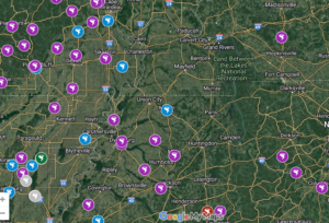
Storm shelters come in a variety of forms. Some communities have built crate-style shelters and cubes or capsules. Those two shelters typically hold 10-35 people, Ceecee wrote on his website. He coded the crate shelters as lime green and the cubes or capsules as yellow. Cylinder-style shelters, coded as dark green on his map, can hold 60-90 people. Other shelters are designated rooms at fire or police stations, and those can be either above-ground or underground. He coded those as red or dark blue. Larger shelters can be community or school facilities.
Ceecee has to investigate the types of shelters to ensure that they meet FEMA standards for inclusion on his map.
“I can’t travel to every nook and cranny of the whole country down these back country roads,” Ceecee said in a Zoom interview with the 270 Stories team. “But I can visually tell through (Google) StreetView or through Google Earth or from TV images if it’s recent if they do a TV picture or news article and show the picture, I’ll add it.”
270 Stories reporter Grace Boatright has this audio story about Ceecee’s quest to inform the public about tornado shelters.


1 comment
Mississippi meteorologist maps tornado shelters – 270 Stories stands out with its original and engaging narrative, making it a standout piece.